
Published by Jeremy. Last Updated on June 9, 2026.
Disclaimer: Our site uses demographic data, email opt-ins, display advertising, and affiliate links. Please check out our Terms and Conditions. Pricing, operating hours, or menus may have changed since our initial visit and may not be reflected in subsequent updates. Please confirm these directly with any business prior to visiting. To see more of our content, set us as a Preferred Source in Google.
Although Pittsburgh and southwest Pennsylvania is quite hilly, we are fortunate enough to have a number of fairly flat trails to go biking. Many of these trails are found on former train lines (rail trails), which thanks to their restricted grade makes for prime biking conditions.
In this one, we wanted to share a few of our favorite spots to bike in and around the city. So whether you're simply wanting to take a quick ride around the North Shore River Trail, ride the GAP, or go out for a few miles on a rail trail, this one is for you!
🏨 Book a Hotel in Pittsburgh
- Great Value: Drury Plaza offers excellent prices downtown.
- Good Views: Sheraton Station Square features stellar views from river-view rooms.
- Free Parking: Hampton Inn Strip District includes free parking and a great location.
🏡 Looking for an apartment rental? Find a deal on Airbnb!
The Panhandle Trail

Save This Article!
The Panhandle Trail is a nearly 30-mile long trail that runs from Walkers Mill in Collier Township, PA, to Wierton, WV. This converted rail trail offers a beautiful ride through many boroughs (closer to the city) and countryside (closer to West Virginia) with a small, but nearly consistent grade of about 1% which is most noticeable on the return from West Virginia.
Riders on this trail should note that the sections of the trail in Allegheny County and West Virginia are crushed limestone, while the ~20-mile stretch through Washington County to the border is paved. As such, when biking this one we often like to start in Oakdale (mostly to end at Helicon Brewery right on the trail) and bike towards West Virginia. In doing so you only have about two miles on crushed limestone before the easier-to-navigate paved section begins.
But for those who want scenery, you may find a few more interesting sights in the stretch between Walkers Mill and Oakdale (~ 4-miles).
For those who are looking for infrastructure for snacks and water, note that the boroughs around Oakdale have more options than those found closer to West Virginia. As such, you should stock up with everything you need for the day if heading west on this trail.
For more information on the Panhandle Trail, including a trail map, click here.
The Montour Trail

The Montour Trail runs just over 60-miles from Moon Township to Clairton and features a mix of paved and limestone paths that covers a varied path that includes a mix of bridges, former rail tunnels, and more. On the western side of the trail in McDonald, the Montour train links up with the Panhandle Trail. On the eastern side at Clairton, a ~5-mile road ride will get you to the Great Allegheny Passage.
It should be noted that sections of this trail between Bethel Park and Clairton may still be under construction and require some road connections, so those who are wanting a purely dedicated bike trail may do well sticking closer to the western half of the trail. (Although it is worth noting you'll likely find more tunnels in the stretch between McDonald and Bethel Park!) Likewise, we noted more small potholes and fill-in patches on this trail over others in this guide, so you may need to pay just a bit closer attention to where you bike here.
For more information about the Montour Trail, including a trail map, click here.
The Butler-Freeport Community Trail

The Butler-Freeport Community Trail is the only rail trail in this guide that runs north to south. This presents a unique scenario where a fair amount of the trail is likely shaded outside of the peak mid-day sun.
What we love most about this 20-mile ride (one-way) is that the grade is quite gradual- no more than 1% at any given time and only over short distances. As such, apart from the crushed limestone trail (and possibly some wet parts after rain), this one is pretty easy to ride for all skill levels.
For those who like a flowing creek, trees, and rock formations, sticking to the trails near Freeport is for you. If you like wide-open spaces, rolling hills, and farmland, the trail near Butler is the place to be. If you do it all, you'll have a wonderful, gradual change of scenery over the entire ride.
It is worth noting that despite the frequent parking areas and cross-streets found on this trail, only one support business is found on the path to sell food, snacks, and more. This is the Derailleur Bike Shop Cafe located about 5-miles south of the Butler trailhead.
For more information on the Butler-Freeport Community trail, including trail map, click here.
North Shore – Three Rivers Heritage Trail

The North Shore section of the Three Rivers Heritage Trail one of our favorites in the city as it offers some fairly stunning views. Along the path you can see great views of the Allegheny River, the Three Sisters Bridges, PNC Park, Pittsburgh's skyline, Acrisure Stadium, the Mr. Rogers Statue, the Carnegie Science Center and the USS Requin, the Three Rivers Casino, and more.
The trail itself runs approximately 9-miles from just before the McKees Rocks Bridge to the riverfront in Millvale, PA and the city's master plan for bike trials has this one set to expand in the near future.

For those who want a bit of a challenge, you add on 6-miles to this one by turning it into a loop once you get to the end of the trail at the McKees Rocks Bridge! To do this, you'll need to do the following (note: some segments of this loop are on surface roads without dedicated bike lanes):
At the end of the trail, turn right out onto Westhall Street. At the first intersection, turn right onto Beaver Avenue and then immediately turn left onto Eckert Street. One block down on Eckert Street here will be a fork in the road by Don's Diner. Veer left to turn onto McClure Avenue and take that approximately 750 feet. Another fork in the road will appear at Young Brothers Bar and you will veer right to continue on Woods Run Avenue.
Woods Run Avenue is approximately 0.5 miles long and as an elevation gain of about 450 feet, so you should expect a fairly steep climb over its distance. Near the top, this one turns into Mairdale Avenue and connects up to Perrysville Avenue at the top of the hill. At the light with Perrysville turn right and it'll be a coast downhill all the way to Federal Street*.
- Want an easier but slightly longer ride? When entering Riverview Park on Woods Run, you'll come to a three way intersection (stop signs). This route would have you continuing straight on Woods Run, but if you turn right on Riverview Avenue you'll be able to bike through the park itself. While longer, the grade is much easier to tackle. When you reach the observatory, you'll exit the park on Riverview Avenue and connect to Perrysville, where you will turn right.
Here, turn right again, follow Federal Street down and around Allegheny Commons, and you'll find yourself at PNC Park to access the river trail again!
*Note: Perrysville Avenue connects up to Federal Street twice. Continue on Perrysville until the second meetup- it'll be a dead end where you can only turn left (uphill) or right (downhill). Turn right and coast your way back to PNC Park.
For more information on the North Shore Section of the Three Rivers Heritage Trail, check out Friends of the River Front.
The Great Allegheny Passage

In this one, we have to give a nod to what is perhaps the longest bike trail in our region. The Great Allegheny Passage connects downtown Pittsburgh (from the Point) to Cumberland, Maryland, and is 150-miles in length- great for a multi-day ride!
Going even further than this, while in Cumberland, the GAP links up to the C&O Canal Trail which continues all the way to Washington DC. Together they offer a combined 334.5 mile ride which most riders will split up over a week or so one way.
While nearly 300 miles of the trail is fairly flat, you do have to climb over one mountain on the Great Allegheny Passage segment. The direction you travel here will surely make a difference as going towards Washington you climb 1,500 feet over 50 miles, while going towards Pittsburgh you climb nearly 2,000 feet in 25 miles! Suffice it to say, there is a reason why most riders prefer to take this trip from Pittsburgh to Washington and not the other way around.
Infrastructure along the Gap and C&O Canal Trail is fairly robust as you pass through many towns which offer services, bed and breakfasts and more. Third-party companies even offer fully-booked tours, return transportation, and luggage transfers for this one so all levels of bikers can be accommodated (although to be fair, you really should be prepared for multiple 60-mile days so it is best for some long-distance training).
Be sure to pick up the most recent TrailGuide for the GAP to stay up-to-date with the latest offerings along the trail.
The Westmoreland Heritage Trail

For our next trails, we're heading a bit further out of the city. First up is the Westmoreland Heritage Trail which runs about 17 miles in total and is split between two sections- roughly eight miles between Delmont and Saltsburg and nine miles between Export and Trafford.
Like other trails in this guide this former rail trail is constructed mostly of crushed limestone, is relatively flat (although you'll notice a fairly consistent grade going away from Saltsburg and away from Trafford), and will have you out in the beauty of nature within moments of hitting the trail.
For those who like to be alone amongst the trees, the Delmont to Saltsburg segment is to you. At roughly the halfway point you'll find a pig farm, and on the Saltsburg side you'll find a few rivers and creeks and a connecting point to the West Penn Trail. For those who want a bit more, the Export to Trafford section has a good chunk of the trail passing Turtle Creek and has some really stunning views! (For this, you'll need to go a few miles outside of Export to really start getting the scenery, but it starts almost immediately from the Trafford end.)
No matter which section of this trail you hit, you'll be in for a gorgeous outing in nature!
The West Penn Trail

The West Penn Trail is a 17-mile partial rail-trail that connects Saltsburg to Blairsville, PA. While this one has a connection point with the Westmoreland Heritage Trail (above), the trailhead for this one begins a few miles to the west such that starting at the connector would only be about 13-miles one-way in total.
This trail is, for lack of a better word, rough. It has conditions that run from paved stretches all the way to large gravel, fine gravel, and everything in between. The hardest part of this trail is the middle five miles which are no longer a rail-trail but instead go up and over several hills and is something mountain bikers would likely find more enjoyable over leisurely bikers. We had to walk ours up steep grades about ten times in our round-trip outing.
Still, this one offers stellar views of the Conemaugh River (especially the five miles nearest Blairsville) and, for those who tackle the middle segment, some pretty impressive views of Conemaugh Dam. That being said, this one may be best for a partial ride and a drive over to the dam versus tackling the whole thing.
The Hoodlebug Trail

If you find yourself in need of a bike trail northeast of the city, you may want to head to Indiana, PA, to check out the ~10-mile Hoodlebug Trail. This converted rail trail runs north-south from Indiana to Black Lick, PA, and connects up to the Ghost Town Trail at its southern terminus.
The scenery here is constantly changing between little boroughs, industrial areas, rolling hills, and crossings of several creeks and rivers. The trail is mostly crushed limestone and relatively well maintained; however, the last mile or so near Black Lick is extremely rocky by bike trail standards. We'd also say there is a relatively consistent upward grade going towards Indiana, but these are often slightly hilly segments such that you take a quick climb followed up by a nice drop to gain some speed.
Perhaps one of the best parts of this trail is that Levity Brewing can be found right off of it about a mile from the Indiana terminus- great for a post-ride beer. Noble Stein can also be reached via a short ride on surface roads from the northern trailhead and Voodoo has a location a few blocks away as well!
The Armstrong Trail

The aptly named Armstrong Trail is a 35-mile rail-trail in Armstrong County- roughly an hour northeast of downtown Pittsburgh.
This trail is remarkably flat and follows its way around the eastern bank of the Allegheny River. While river views here tend to only open up north of Kittanning (about seven miles north of Ford City), you can also see great river adjunct constructions like an old iron furnace, lock and dams, power stations and more throughout the ride.
The Redbank Valley Trail

The Redbank Valley Trail is a roughly 42-mile rail trail that runs from East Brady, PA (connecting to the Armstrong Trail, above), to Brookville, PA, by I-80.
Given its length, many riders opt to explore the western side of this trail for its beautiful scenery, views of Redbank Creek, two tunnels, and more, making for an easy 40-mile roundtrip between East Brady and New Bethlehem. Just be sure to take a flashlight (or have charge on your phone) as the tunnels in this one can get almost pitch black when biking through!
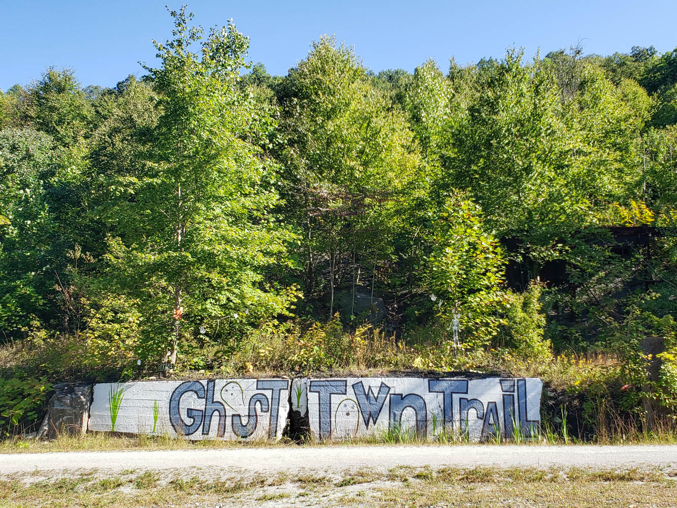
The Ghost Town Trail

The Ghost Town Trail starts in Black Lick, PA, just at the southern terminus of the Hoodlebug (above). But instead of running north-to-south, this one runs approximately 36 miles east (with 10 more miles on an extension trail that breaks off).
During our first visit to this one, we rode 25-miles out to Nanty Glo and were impressed with the wide array of sights you can see from gorgeous creeks, old coal deposits, a historic iron furnace, beautiful little boroughs, and so much more. Add in the fact that the ride was a steady 1% up for the first 20 miles (and a bit more intense 2-3% up for the next few), and the trail made for an easier return that allowed us to set a new distance record all the same.
We do not say this one lightly, but the Ghost Town Trail may be our very favorite ride out of all of the ones featured in this list!
The Bike Trail at Moraine State Park

When you think of Moraine State Park, odds are good you think of water-based activities thanks to the beautiful Lake Arthur that prominently resides within the park. But this gorgeous park is also home to a 7-mile (one-way) bike trail on the north shore that is simply a fun one to ride.
The reason for this is that the paved bike trail has frequent tight bends and small bunny hills (10-20 feet) that you pass through. If you catch enough speed on the first hill, you can use the momentum to take you to the top of the next (for many of them, at least), and makes for a really fun ride. Throw in beautiful lake views and other vistas with surrounding nature, and you have quite the fun outing at the park.
Just be sure to get a treat at The Snowman (seasonal) on your way back home!
Have a favorite bike trail we haven't featured above? Comment below to let us know about it. We'll go for a ride and then include it in this article!
Want to ride surface roads instead of proper trails? Check out the PedalPGH charity event each August!
You might want to check out the section of the abandoned turnpike, out past Breezewood. https://en.wikipedia.org/wiki/Abandoned_Pennsylvania_Turnpike
FYI – you will need to wear headlamps to navigate thru the 2 tunnels.
The Great Allegheny Passage, in particular the section between Connellsville thru Ohiopyle to Confluence, is the nicest piece of bike trail within an hour drive of Pittsburgh. (Ghost Town Trail has some pretty stretches, but it’s not as unspoiled as the GAP).
Another one to add to the list is the Armstrong Trail. Start from Ford City and bike along the Allegheny River. Connects to the Redbank Trail, which is very nice and has several cool tunnels.
Deckers Creek trail in Morgantown WV. is quite scenic.
We love the very scenic Roaring Run Trail just east of
Apollo to Avonmore. It follows the Kiskimenatas River and there’s also boat launch for kayaks and canoes at Apollo trailhead and in quiet town of Avonmore. With a little advanced planning you could kayak down and bike back!
Why not try the Redbank Valley trail? It is closer than some of these trails mentioned and was PA 2014 trail of the year. I suggest the section between Lawsonham and New Bethlehem Take a light for the tunnels.